How Big is Aruba? Size, Dimensions, & Population

Aruba is about 20 miles (32 kilometers) long and up to 6 miles (10 kilometers) wide. The island covers approximately 69 square miles (180 square kilometers). That makes Aruba a relatively small Caribbean island, but there’s plenty to see and do.
You can drive from one end of Aruba to the other in a relatively short time, yet the island has dozens of beaches, natural attractions, restaurants, neighborhoods, hotels, and other places to explore.
So exactly how big is Aruba? Let’s look at Aruba’s size, dimensions, population, driving distances, and how the island compares with other destinations.
Disclosure: Some of the links below may be affiliate links. At no additional cost to you, we may earn a small commission if you make a purchase.
How Big is Aruba?
Aruba has a total land area of approximately: 69 square miles (180 square kilometers).
The island is approximately:
- 20 miles (32 km) long
- Up to 6 miles (10 km) wide
- 69 square miles (180 km²) in area
Aruba is shaped somewhat like a long, narrow island, with its main population centers and tourist areas concentrated along the western and southern coasts.
The island’s relatively small size is one of its advantages for travelers. You can stay in one part of Aruba and easily visit attractions in another part of the island during the same vacation.
How Long is Aruba?
Aruba is approximately 20 miles (32 kilometers) long from its northernmost to southernmost points. The exact distance can vary slightly depending on which points you use to measure the island.
For travelers, the more useful question is often how long it takes to drive from one part of Aruba to another.
How long does it take to drive across Aruba?
You can generally drive across much of Aruba in 30–45 minutes, depending on where you start, where you’re going, traffic, road conditions, and stops along the way.
Driving from the northern part of the island near Arashi and the California Lighthouse to the southern end near Baby Beach takes longer than driving between the main resort areas. This is one reason renting a car can be useful if you want to explore more than the immediate area around your hotel.
How Wide is Aruba?
Aruba is approximately 6 miles (10 kilometers) wide at its widest point. Because the island is relatively narrow, you are never particularly far from the coast. However, the landscape changes considerably as you travel across the island.
The western and southern areas are home to many of Aruba’s most popular beaches, hotels, and restaurants, while the eastern and northern areas tend to be more rugged and less developed.
How Many Square Miles Is Aruba?
Aruba covers approximately 69 square miles (180 square kilometers).
For comparison:
| Destination | Approximate area |
|---|---|
| Aruba | 69 sq mi / 180 km² |
| Manhattan | ~23 sq mi / 59 km² |
| Washington, D.C. | ~68 sq mi / 177 km² |
| Brooklyn | ~70 sq mi / 181 km² |
| Curaçao | ~171 sq mi / 444 km² |
| Bonaire | ~111 sq mi / 288 km² |
These comparisons are approximate and can vary depending on whether a source measures land area or total area.
Aruba vs. Manhattan
Aruba is about three times the size of Manhattan by area. Despite being relatively small, Aruba’s long, narrow shape means the island covers considerably more ground than the 69-square-mile number might suggest.
Aruba vs. Washington, D.C.
Aruba and Washington, D.C. are surprisingly similar in total area. Aruba covers approximately 69 square miles, while Washington, D.C. covers roughly 68 square miles. The big difference is that Aruba is an island with a much more spread-out population and a very different landscape.
Aruba vs. Curaçao
Curaçao is substantially larger than Aruba. At approximately 171 square miles, Curaçao has about 2.5 times the land area of Aruba. Both islands are part of the ABC Islands, but Curaçao’s larger size contributes to a different travel experience.
Aruba vs. Bonaire
Bonaire is also larger than Aruba, covering approximately 111 square miles. That makes Bonaire about 1.6 times the size of Aruba. Like Aruba, Bonaire has a relatively dry landscape and strong trade winds.
How Long Does It Take to Drive Around Aruba?
Aruba’s size makes it relatively easy to explore by car. A complete drive around the island can take several hours if you stop at beaches, attractions, viewpoints, restaurants, and other places along the way. If you drove without stopping, the time would depend heavily on the exact route.
In reality, most visitors shouldn’t think of Aruba as an island that you simply “drive around” once. The more useful approach is to divide the island into areas and explore them over several days.
Popular Driving Distances in Aruba
Approximate driving times can vary considerably with traffic and your exact starting point, but these examples give you an idea of the island’s size:
| Route | Approximate drive time |
| Palm Beach → Eagle Beach | 10–15 minutes |
| Palm Beach → Oranjestad | 10–15 minutes |
| Palm Beach → Arashi Beach | 15–20 minutes |
| Palm Beach → Arikok National Park | 30–40 minutes |
| Palm Beach → Baby Beach | 40–50 minutes |
| Oranjestad → Baby Beach | 30–40 minutes |
These are approximate travel times rather than fixed guarantees. If you’re visiting during busy periods, allow extra time for traffic and parking.
How Many People Live in Aruba?
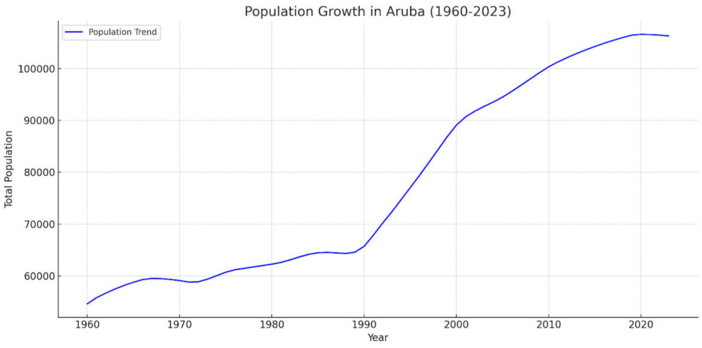
Aruba has a population of approximately 100,000–110,000 people. Most of the population lives in or around the island’s urban and residential areas, particularly near Oranjestad and the more developed western and southern parts of the island. For such a small island, Aruba has a relatively high population density.
This is one reason the main tourist areas can feel much busier than Aruba’s more remote eastern and northern areas.
What Percentage of Aruba Is Developed?
Aruba has developed areas concentrated primarily around the western and southern coasts. The island’s major tourist zones include:
- Palm Beach
- Eagle Beach
- Noord
- Oranjestad
- Druif
- Manchebo
- Savaneta
Much of the eastern side of Aruba is more rugged and less developed. Arikok National Park alone covers roughly 20% of the island, helping preserve a large area of Aruba’s natural landscape.
This contrast is one of the interesting things about Aruba. You can be surrounded by large hotels, restaurants, casinos, and shops in Palm Beach and then reach rugged desert-like terrain and natural landscapes relatively quickly.
Does Aruba Feel Small?
Yes and no. Aruba is physically small, but it doesn’t necessarily feel tiny when you’re visiting. The major resort areas are concentrated along the western coast, while the island’s natural attractions are spread across other areas. You can spend an entire day exploring:
- Eagle Beach
- Oranjestad
- Arikok National Park
- Ayo Rock Formation
- Baby Beach
- Mangel Halto
and still have plenty left to see.
The island’s size simply means that these places are relatively accessible from one another.
Where Are Most Visitors Staying?
Most visitors stay along Aruba’s western and southwestern coast. The main hotel areas include:
1. Palm Beach
Palm Beach is Aruba’s main high-rise resort district. It has a large concentration of:
- Hotels
- Resorts
- Restaurants
- Bars
- Shops
- Casinos
- Watersports
Eagle Beach & Other Low-Rise Hotels in the Area
Eagle Beach is known for its wide sandy beach and lower-rise accommodations. It tends to offer a quieter atmosphere than Palm Beach while remaining close to restaurants and attractions.
The Low-Rise Hotel Area near Eagle Beach also includes many smaller resorts and hotels.
Oranjestad
Aruba’s capital has hotels, restaurants, shopping, museums, and the cruise port. For a detailed breakdown of Aruba’s different hotel areas, see our guide to Where to Stay in Aruba.
Does Aruba Have Different Regions?
Aruba doesn’t have large geographic regions in the same way that a large country does, but travelers commonly divide the island into areas based on geography and development.
Northern Aruba
The northern part of the island includes areas such as:
- Noord
- Palm Beach
- Malmok
- Arashi
- California Lighthouse
This area contains many popular hotels, beaches, restaurants, and attractions.
Central Aruba
Central Aruba includes Oranjestad and areas surrounding the capital. This is where you’ll find much of the island’s commercial activity, shopping, government buildings, and historic sites.
Southern Aruba
Southern Aruba includes:
- Savaneta
- Mangel Halto
- San Nicolas
- Baby Beach
This part of the island has a more local feel in many areas and includes some of Aruba’s most popular snorkeling and swimming spots.
Eastern Aruba
Eastern Aruba is more rugged and less developed. Much of Arikok National Park is located in this part of the island, along with rugged coastline, natural pools, caves, and other natural attractions.
How Big is Aruba Compared With Other Caribbean Islands?
Aruba is smaller than many of the Caribbean islands travelers know.
For example:
- Puerto Rico is much larger than Aruba.
- Jamaica is dramatically larger.
- Curaçao is about 2.5 times larger than Aruba.
- Bonaire is about 1.6 times larger.
- Barbados is about 4 times larger.
Aruba’s small size is one reason it is easy to explore during a one-week vacation. You don’t need to spend hours driving between different parts of the island.
Is Aruba Bigger than Curaçao?
No. Curaçao is considerably larger than Aruba. Aruba covers approximately 69 square miles, while Curaçao covers approximately 171 square miles. That means Curaçao has roughly 2.5 times the land area of Aruba.
Both islands are part of the ABC Islands and are located in the southern Caribbean, but Curaçao offers a more geographically spread-out experience.
Is Aruba Bigger than Bonaire?
No. Bonaire is larger than Aruba. Bonaire covers approximately 111 square miles compared with Aruba’s approximately 69 square miles. Bonaire therefore has about 1.6 times the land area of Aruba.
Why Aruba’s Size Matters for Your Vacation
Aruba’s relatively small size is a major advantage for travelers. You can stay at a resort in Palm Beach and still visit:
- Arashi Beach
- Eagle Beach
- Oranjestad
- Mangel Halto
- Arikok National Park
- Baby Beach
without spending hours on the road.
It also makes Aruba a good destination for travelers who want to combine relaxation with sightseeing. You don’t have to choose between staying at a beautiful beach and exploring the island’s natural attractions.
Do You Need a Car in Aruba?
Not necessarily, but having a car can make exploring the island much easier.
If you plan to spend most of your vacation at your resort, visit nearby restaurants, and take organized tours, you may not need to rent a car. A rental car becomes more useful if you want to:
- Visit multiple beaches
- Explore Arikok National Park
- Visit Baby Beach
- See the California Lighthouse
- Explore San Nicolas
- Find less crowded beaches
- Travel on your own schedule
Aruba’s small size means you won’t be spending hours driving between destinations. For more information, see our guide to Renting a Car in Aruba.
What is Aruba’s Highest Point?
Aruba’s highest point is Mount Jamanota, which reaches approximately 617 feet (188 meters) above sea level. The mountain is located in the eastern part of the island near Arikok National Park.
Aruba’s relatively low elevation is another reason the island looks and feels different from mountainous Caribbean destinations.
How Big is Aruba’s Coastline?
Aruba has approximately 26 miles (42 kilometers) of coastline, although the exact figure can vary depending on how the coastline is measured.
The island’s coastline includes sandy beaches, rocky shores, cliffs, natural bridges, mangroves, and protected bays. The western and southern coasts are generally calmer and contain many of Aruba’s most popular swimming beaches. The eastern coast faces the open Caribbean and has a much rougher shoreline, with strong waves and dramatic coastal scenery.
Aruba’s Size at a Glance
Here’s the quick version:
| Measurement | Aruba |
|---|---|
| Area | ~69 sq mi / 180 km² |
| Length | ~20 mi / 32 km |
| Maximum width | ~6 mi / 10 km |
| Highest point | Mount Jamanota — ~617 ft / 188 m |
| Population | ~100,000–110,000 |
| Location | Southern Caribbean |
| Nearest mainland country | Venezuela |
| ABC Islands | Aruba, Bonaire & Curaçao |
Frequently Asked Questions About Aruba’s Size
So, How Big Is Aruba?
Aruba is approximately 69 square miles (180 square kilometers), about 20 miles long and up to 6 miles wide.
It’s small enough that you can explore much of the island during a single vacation, but large enough to offer a surprising variety of beaches, neighborhoods, natural attractions, restaurants, hotels, and activities. That’s one of Aruba’s biggest advantages as a vacation destination.
You can spend the morning relaxing on Eagle Beach, explore Arikok National Park in the afternoon, and have dinner in Palm Beach that evening, without spending most of your day in the car.
Explore More of Aruba
Location of Aruba See exactly where Aruba is located, with maps, coordinates, neighboring countries, and more.
Countries and Islands Near Aruba Discover Aruba’s closest neighbors, including Venezuela, Curaçao, and Bonaire.
ABC Islands Learn more about Aruba, Bonaire, and Curaçao and how the three islands compare.
What Continent Is Aruba In? Understand Aruba’s geographic relationship to South America and the Caribbean.
Is Aruba a Country? Learn about Aruba’s political status within the Kingdom of the Netherlands.
Where to Stay in Aruba Find the best areas and hotels for your Aruba vacation.
Have additional questions about the size of Aruba?
Let us know in the comments!